Columbia University Libraries Digital Collections: The Real Estate Record
Use your browser's Print function to print these pages.
Real estate record and builders' guide: [v. 99, no. 2558: Articles]: March 24, 1917
Text version:
Please note: this text may be incomplete. For more information about this OCR, view About OCR text.
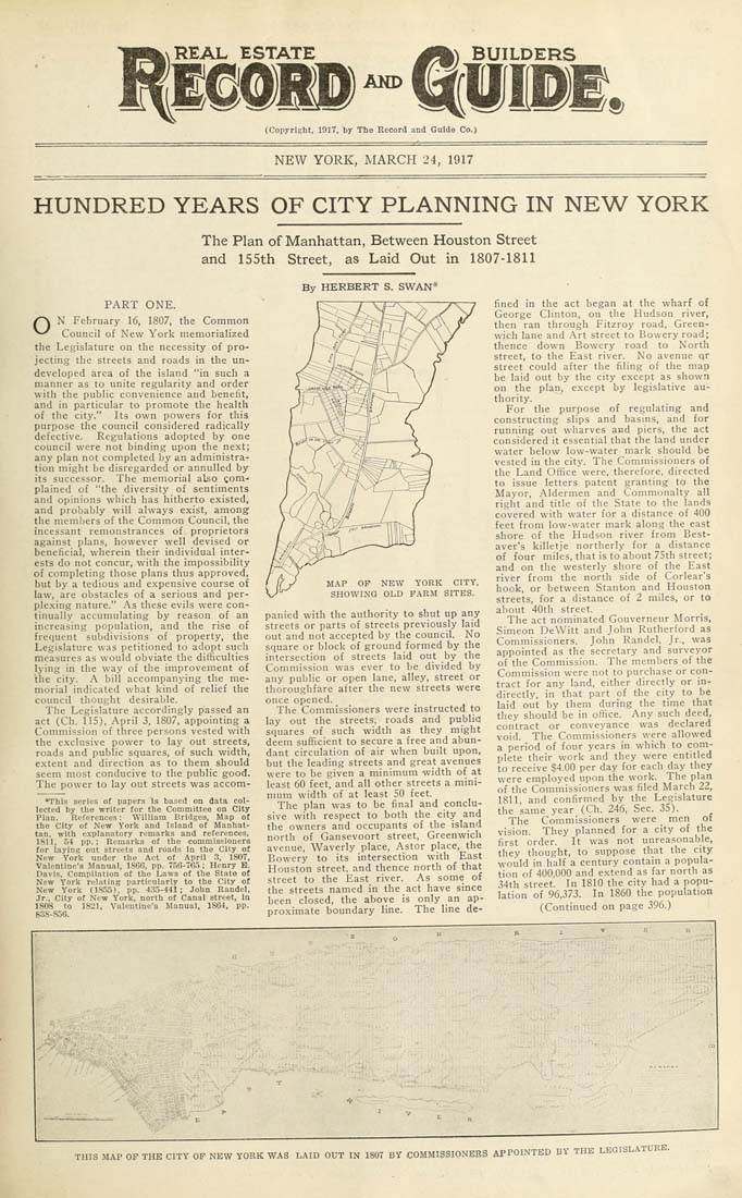
AND (Copyright, 1917, by The Record and Guide Co.) NEW YORK, MARCH 24, 1917 HUNDRED YEARS OF CITY PLANNING IN NEW YORK The Plan of Manhattan, Between Houston Street and 155th Street, as Laid Out in 1807-1811 By HERBERT S. SWAN* PART ONE. /^ N February 16, 1807, the Common ^^ Council of New York memorialized the Legislature on the necessity of pro¬ jecting the streets and roads in the un¬ developed area of the island "in such a manner as to unite regularity and order with tlie public convenience and benelit, and in particular to promote the health of the city." Its own powers for this purpose the council considered radically defective. Regulations adopted by one council were not binding upon the ne.xt; any plan not completed by an administra¬ tion might be disregarded or annulled by its successor. The memorial also gom- plained of "the diversity of sentiments and opinions which has hitherto existed, and probably will always exist, among the members of the Common Council, the incessant remonstrances of proprietors against plans, however well devised or beneficial, wherein their individual inter¬ ests do not concur, with the impossibility of completing those plans thus approved, but by a tedious and expensive course of law, are obstacles of a serious and per¬ plexing nature." As these evils were con¬ tinually accumulating by reason of an increasing population, and the rise of frequent subdivisions of property, the Legislature was petitioned to adopt such measures as would obviate the difficulties lying in the way of the improvement of 'the city. A bill accompanying the me¬ morial indicated what kind of relief the council thought desirable. The Legislature accordingly passed an act (Ch. 115), April 3, 1807, appointing a Commission of three persons vested with the exclusive power to lay out streets, roads and public squares, of such width, extent and direction as to them should seem most conducive to the public good. The power to lay out streets was accom- *ThIs series of papers is based on data col¬ lected by the writer for the Committee on City Plan. References: William Bridges, Map of the City of New York and Island of Manhat¬ tan, with explanatory remarks and references, 1811, 54 pp.; Remarks of the commissioners for laying out streets and roads in the City ot New York under tbe Act ot April 3, 1807, Valentine's Manual, 1806, pp. 756-763 ; Henry B. Davis. Compilation of the Laws of the State of New York relating particularly to the City of New York (1853), pp. 435-441; John Randel, Jr., City of New York, north of Canal street. In 1808 to 1821, Valentine's Manual, 1864, pp. 838-856. MAP OF NEW YORK CITY, SHOWING OLD FARM SITES. panied with the authority to shut up any streets or parts of streets previously laid out and not accepted by the council. No square or block of ground formed by the intersection of streets laid out by the Commission was ever to be divided by any public or open lane, alley, street or thoroughfare after the new streets were once opened. The Commissioners were instructed to lay out the streets, roads and public! squares of such width as they might deem sufficient to secure a free and abun¬ dant circulation of air when built upon, but the leading streets and great avenues were to be given a minimum width of at least 60 feet, and all other streets a mini¬ mum width of at least 50 feet. The plan was to be final and conclu¬ sive with respect to both the city and the owners and occupants of the island north of Gansevoort street, Greenwich avenue, Waverly place, Astor place, the Bowery to its intersection with East Houston street, and thence north of that street to the East river. As some of the streets named in the act have since been closed, the above is only an ap¬ proximate boundary line. The line de¬ fined in the act began at the wharf of George Clinton, on the Hudson river, then ran through Fitzroy road, Green¬ wich lane and Art street to Bowery road; thence down Bowery road to North street, to the East river. No avenue qr street could after the filing of the map be laid out by the city except as shown on the plan, except by legislative au¬ thority. For the purpose of regulating and constructing slips and basins, and for running out wharves and piers, the act considered it essential that the land under water below low-water mark should be vested in the city. The Commissioners of the Land Office were, therefore, directed to issue letters patent granting to the Mayor, Aldermen and Commonalty all right and title of the State to the lands covered with water for a distance of 400 feet from low-water mark along the east shore of the Hudson river from Best- aver's killetje northerly for a distance of four miles, that is to about 75th street; and on the westerly shore of the East river from the north side of Corlear's hook, or between Stanton and Houston streets, for a distance of 2 miles, or to about 40th street. The act nominated Gouverneur Morris, Simeon DeWitt and John Rutherford as Commissioners. John Randel, Jr., was appointed as the secretary and surveyor of the Commission. The members of the Commission were not to purchase or con¬ tract for any land, either directly or in¬ directly, in that part of the city to be laid out by them during the time that tliey should be in office. Any such deed, contract or conveyance was declared void. The Commissioners were allowed a period of four years in which to com¬ plete their work and they were entitled to receive $4.00 per day for each day they were employed upon the work. The plan of the Commissioners was filed March 22, 1811, and confirmed by the Legislature the same year (Ch. 246, Sec. 35). The Commissioners were men of vision. They planned for a city of the first order. It was not unreasonable, they thought, to suppose that the city would in half a century contam a popula¬ tion of 400,000 and extend as far north as 34th street. In 1810 the city had a popu¬ lation of 96,373. In 1860 the population (Continued on page 396.) THIS MAP OF THB CITY OF NEW YORK WAS LAID OUT IN 1807 BY COMMISSIONERS APPOINTED BY THE LEGISLATURE.